The Latest Innovations in Laser Scanning Technology

In terms of on-site data collection for construction, real estate, engineering, and architectural purposes, nothing beats the speed and accuracy of today's 3D laser scanners. The concept was introduced in the 1970s as a feasible method for surveying and topographical mapping.
As commercial lasers and computing hardware continued to evolve, significant advancements were made in the development of light detection and ranging (LiDAR) systems. During the early 1990s, one company, Cyra Technologies, proved instrumental in perfecting the equipment that would set the standard for some of the best imaging scanners today.
In 2000, Leica Geosystems acquired Cyra Technologies and refined the company's pioneering vision, contributing to the company's current range of in-demand products.
Spatial Technologies is a proud distributor of Leica Geosystems' next-generation surveying and scanning equipment, providing sales and support for businesses across Western Canada. Here are some of the latest products making waves in the industry.
Leica BLK2GO - The Ultimate in Mobile Convenience
It wasn't so long ago that even the most cutting-edge, expensive LiDAR scanning tools demanded a high degree of care, attention, and experience in carrying out the work. However, the Leica BLK2GO has simplified the process significantly, improving scanning times and the resulting output.
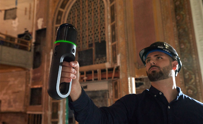
The Leica BLK2GO is one of the most remarkable scanning tools you'll find today for indoor and outdoor mapping! Whether the work takes you underground or you're dealing with a large-scale multi-level structure, this sleek, rechargeable, handheld device delivers consistently exceptional results by simply walking around the location. Weighing a mere 1.7 lbs, you get 6 hours of internal memory, a built-in point-and-shoot camera for additional documentation, and handy one-button operation.
The unit's true standout is its GrandSLAM technology, a trifecta of winning innovation that includes LiDAR SLAM (laser detection), Visual SLAM (camera input), and IMU (inertial measurement unit) technologies for the most impressive simultaneous localization and mapping you'll find anywhere!
The Leica BLK2GO does a fantastic job of automatically recalibrating its location in relation to your movement within the 3D space while capturing point clouds in real time. Not only do you get a product that's incredibly easy to use, but its mobile capabilities allow you to document specific objects as you walk around them. You get quick assessments of as-built locations, floor layouts, square footage counts, and more to support your services.

Leica BLK360 - When Speed Matters
If you're not averse to using a tripod, this terrestrial laser scanner is well-suited for any location. Utilizing a slick design with four 13-megapixel cameras and 5-bracket HDR imaging capture, this model provides rapid scanning for all your spherical imagery and laser scanning needs.
From visual effects data sets to tricky zoning tolerances, if time is of the essence (and when is it not?), the Leica BLK360 offers ultra-fast scanning and data transfers of locations for different industries.
How fast is the BLK360? With the push of a button, you can capture detailed 3D environments in 20 seconds or less under any lighting conditions. You'll save countless hours!
In addition, the company's patented visual inertial system (VIS) technology automatically tracks your individual scans, combining the 3D coordinates for seamless data registration. This capability is a proven time saver on site. If you prefer to complete your scans in the field rather than back at the office, the Leica BLK360 is the model you want!
Architects, design agencies, contractors, and engineering firms in need of on-site as-built surveying will marvel at the Leica BLK360's impressive speed and accuracy (4 mm @ 10 m), which is invaluable in detecting discrepancies in designs and construction planning and preventing costly errors.
BLK ARC - Bolstering Your Remote Operation
Lecia Geosystems' forward-thinking range of products continues to push the surveying industry in new and exciting directions.
If your on-site scanning objective involves a drone (UAV) or autonomous scanning via robotic carriers, BLK ARC will enhance your robotic navigation. However, you don't necessarily require a robotic carrier to use this device.
Each robust unit measures a compact 183.6 mm in height and 92.5 mm from front to back. Weighing only 690 grams, the BLK ARC was explicitly designed for integrations with other Leica innovations (Leica Cyclone 3DR software) and third-party robotics products, including the RB-WATCHER from Robotnik, ANYmal from ANYbotics, and Boston Dynamics' four-legged autonomous robotic canine named Spot, a unit capable of negotiating stairs and other tricky terrain.
Employing Leica Geosystems GrandSLAM technology, BLK ARC empowers remote users with offline path and scan planning. Now, you explore hazardous conditions with additional confidence. BLK ARC includes static and mobile scanning capabilities and will improve your robot’s overall precision.
BLK ARC includes Leica Geosystems' patented GrandSLAM technology
and is controlled using a simple, browser-based interface (BLK ARC UI) for intuitive operation for all your autonomous reality capture tasks.
The Future of Laser Scanning Is Here - Don’t Get Left Behind
If your company is looking to enhance the quality of its service offerings or is considering purchasing scanning equipment that will negate your reliance on outside contractors, Spatial Technologies can discuss the best options for your industry.
Contact our sales staff today to learn more!