


- Regular price
- $0.00
- Sale price
- $0.00
- Regular price
-
- Unit price
- per
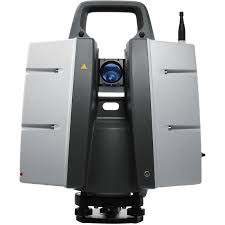
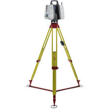
For industry professionals looking to scan inaccessible places and find new business opportunities, Leica ScanStation P50 is the fastest and safest, long range 3D laser scanner. Unlike any other laser scanner, the P50 solution maximises productivity by scanning inaccessible places at a safe position on site, reducing time in the field with less setups.
As part of the Leica Geosystems 3D Reality Capture solution, the Cyclone FIELD 360 app links the 3D data acquisition in the field with the ScanStation P50 laser scanner and final data registration in the office with Cyclone REGISTER 360. One-site, users can now automatically capture, register and examine scan and image data.
The right choice
Whether you 3D capture the world’s tallest buildings, document the widest infrastructure objects or scan the biggest open pit mines, you know long range scanning will be essential for your job. Adding long range scanning capability to the market leading ScanStation P-series, the new Leica ScanStation P50 is the right choice, because every detail matters.
High performance
The extremely durable new Leica ScanStation P50 performs even under the toughest environmental conditions, such as under extreme temperatures ranging from -20°C to + 50°C and complies with the IP54 rating for dust and water resistance.
Scan inaccessible places
The Leica ScanStation P50 delivers highest quality 3D data and HDR imaging at an extremely fast scan rate of 1 mio points per second at ranges of > 1 km. Unsurpassed range and angular accuracy paired with low range noise and survey-grade dual-axis compensation form the foundation for highly detailed 3D colour point clouds mapped in realistic clarity.
Complete scanning solution
Leica Geosystems offers the new Leica ScanStation P50 as an integrated part of a complete scanning solution including hardware, software, service, training and support. 3D laser scanner data can be processed in the industry’s leading 3D point cloud software suite, which consists of Leica Cyclone stand-alone software, Leica JetStream, Leica CloudWorx plug-in tools for CAD systems and the cost-free Leica TruView.
No Video added yet.


No What's included added yet.
- Choosing a selection results in a full page refresh.
- Press the space key then arrow keys to make a selection.
